01 / REGIONALCatchment-scale insight
Regional assessment
Fast answers for catchment-scale questions.
- Water balances
- Runoff and recharge
- Water availability
- Scenario testing
One catchment. One connected system.
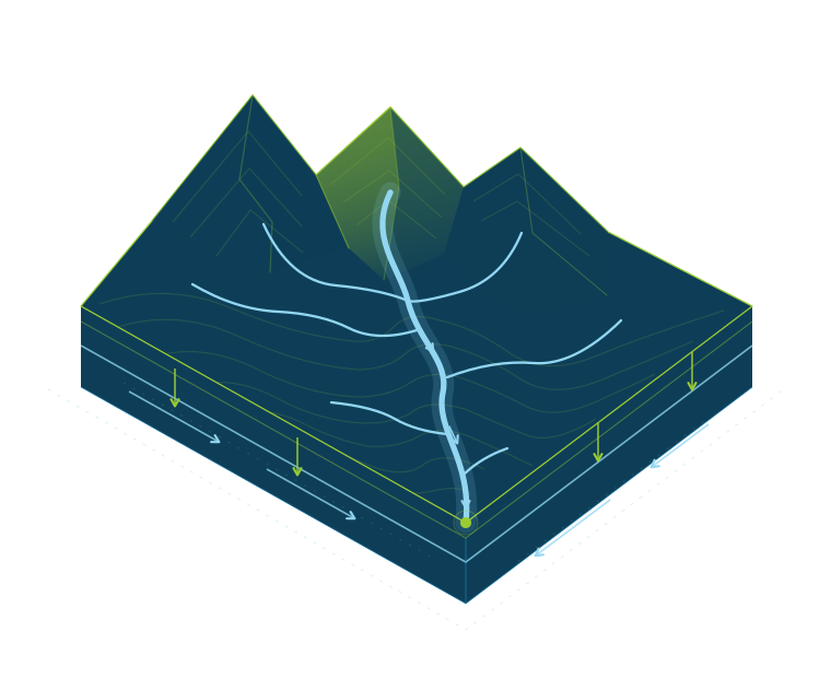
Hydro One connects surface water, soil water, groundwater and water demand in a single modelling framework.
One hydrological system
Hydro One connects surface water, soil water, groundwater, and water demand in a single modelling framework.
Choose your level of detail
Scale your modelling from rapid regional assessments through to fully coupled physical simulation.
Fast answers for catchment-scale questions.
Physics-based modelling for complex investigations.
From surface water, through the unsaturated zone, to the aquifer.
Explore the six modules by water-system component or modelling question.
6 modules
Rainfall, runoff and flooding
Simulate overland and floodplain flow with a two-dimensional, first-order finite-volume solver of the full shallow-water equations.
Where will floodwater go, and how deep will it get?
MethodFull two-dimensional shallow-water equations solved using a first-order finite-volume method (FV1). A local-inertial formulation is available as a reduced-complexity alternative.
OutputsInundation extent, water depths, flow pathways and hydrograph timing.
Assess catchment water balances with fast kinematic routing for runoff, run-on and recharge.
How does water move through a catchment, and what becomes recharge?
MethodKinematic-wave surface routing combined with soil-water balance accounting for catchment-scale runoff and recharge assessment.
Use forWater balances, runoff and recharge, water availability and scenario testing.
Moisture, infiltration, recharge and crop use
Track daily root-zone water storage, evapotranspiration, runoff and groundwater recharge.
How much water stays in the soil or becomes recharge?
MethodConservative Rushton-style daily water balance with soil moisture deficit, evapotranspiration stress and near-surface retention. Scalar and gridded engines include NumPy reference and Warp GPU implementations.
OutputsSoil moisture deficit, evapotranspiration, runoff and recharge.
Connect crop-water demand and irrigation scheduling with delivery capacity, efficiency and abstraction accounting.
When is irrigation needed, and how much water is required?
MethodReference evapotranspiration and crop coefficients, depletion-based scheduling and coupled soil storage. Includes an accelerated fused GPU implementation.
OutputsCrop demand, irrigation applications, soil-water depletion and abstraction requirements.
Aquifers, groundwater exchange and variably saturated flow
Simulate unsaturated and saturated flow through porous media, including infiltration, drainage and wetting fronts.
How does water move through the unsaturated zone?
MethodPressure-head Richards equation with van Genuchten–Mualem hydraulic properties. One- and three-dimensional research solvers with implicit CPU/GPU execution.
InvestigateInfiltration, drainage, wetting fronts, soil hydraulic heterogeneity and recharge processes.
Model groundwater flow in two and three dimensions, including hydraulic heads, transient storage and head-dependent exchanges.
How will aquifer heads, storage and exchanges respond?
MethodSaturated and unconfined groundwater flow with CPU/GPU iterative solvers. The 3D implementation includes Cartesian and terrain-following grids.
OutputsGroundwater heads, aquifer storage, boundary exchanges and scenario response.
AvailabilityThe main branch provides 2D modelling. The 3D implementation is available on the dev branch.
Durney & Fourie (2026)
Environmental Modelling & Software, 204, 107081.Open access
Applied examples + numerical evidence
Explore a flood demonstration, a regional groundwater application and a field-data drainage comparison. Each example illustrates a different modelling capability.
 Orton Bradley / regional landscape
Banks Peninsula · Canterbury
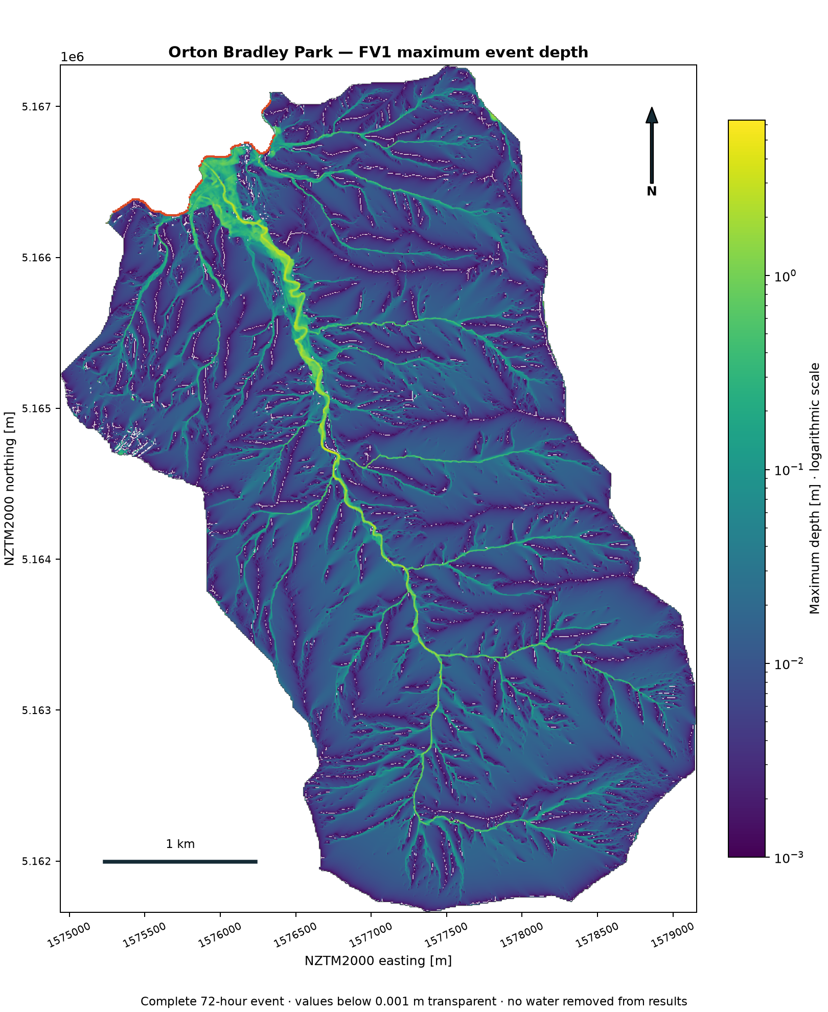
A 72-hour rainfall-driven flood simulation on a 5 m grid, with maximum-depth maps and direct numerical comparisons against LISFLOOD-FP FV1.
Research demonstration. Design-storm simulation and inter-model comparison, not a calibrated observed flood event or an official hazard assessment.
Environment Canterbury · New Zealand
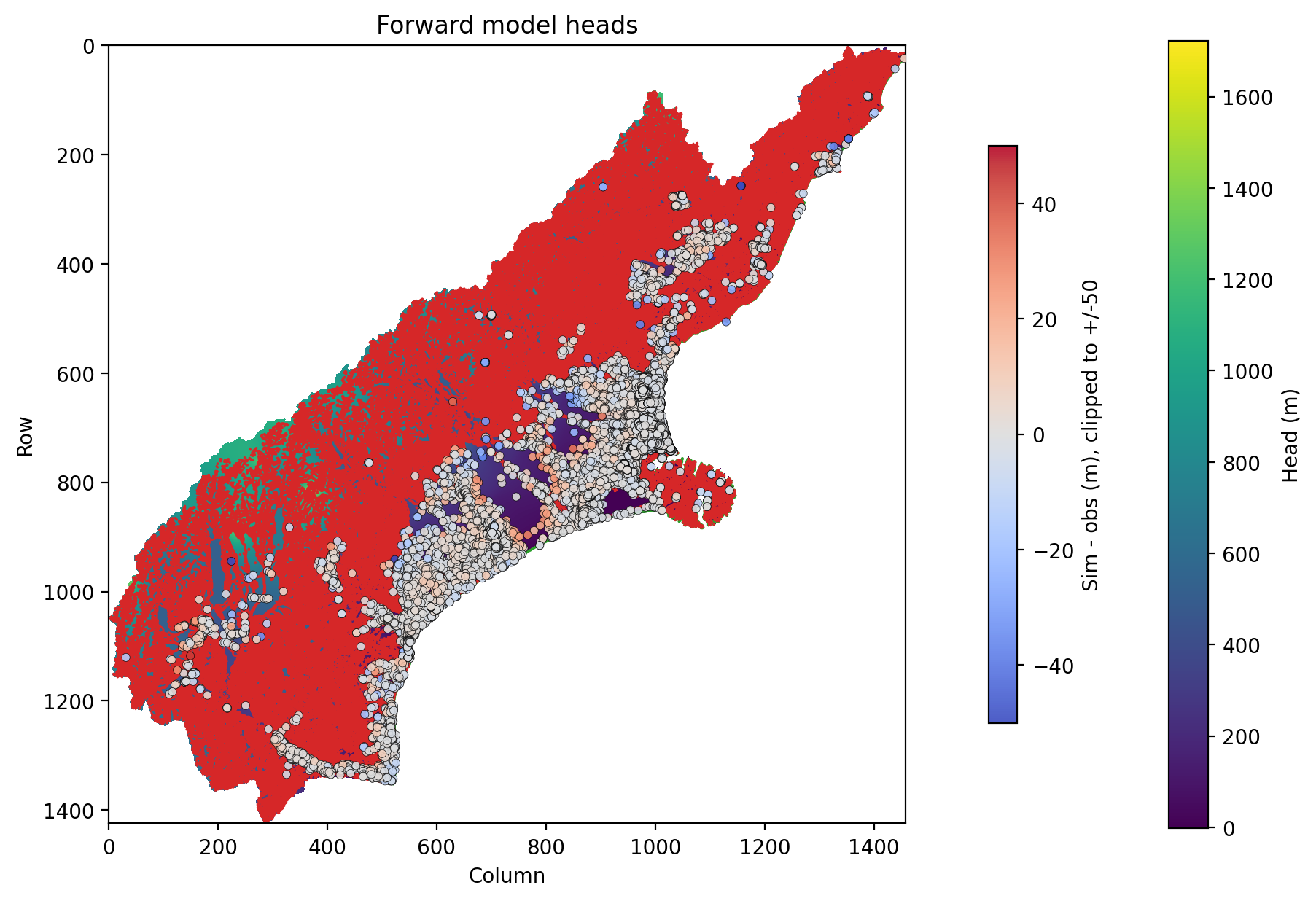
A 45,000 km² steady-state groundwater model developed using DarcyWarp for Environment Canterbury. The model formed the basis for 1,435 accepted, calibration-constrained NSMC realisations.
Canterbury · New Zealand
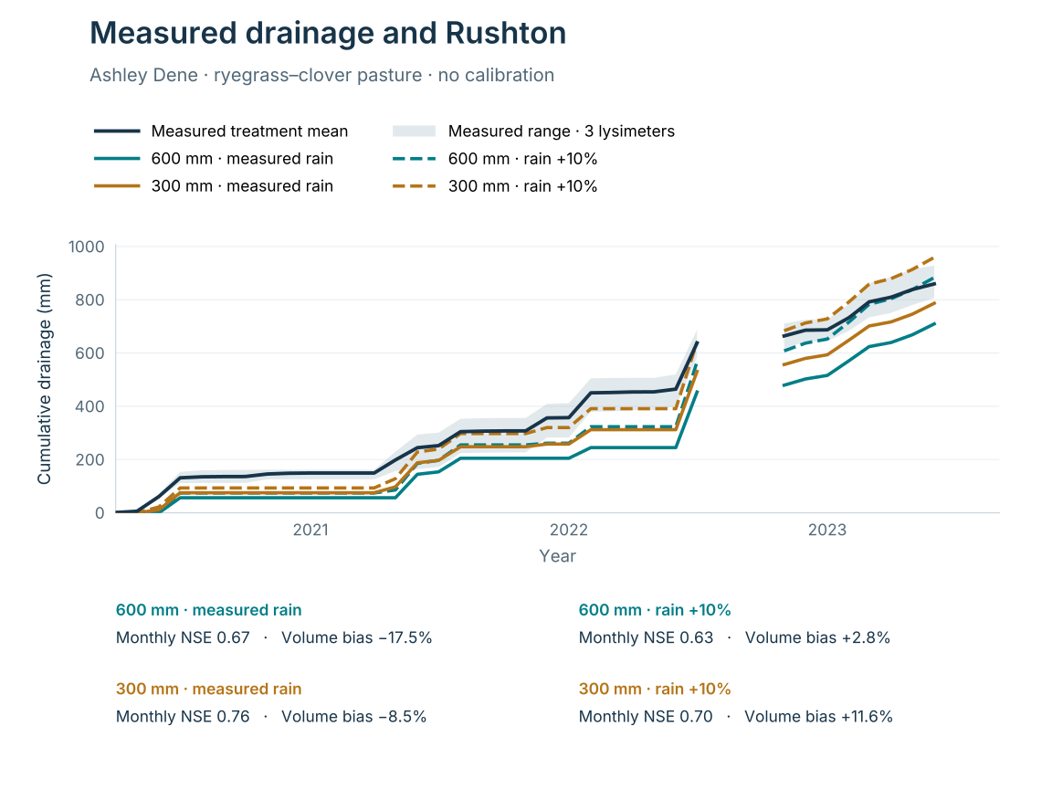
Rushton simulations compared with drainage measured in three ryegrass–clover pasture lysimeters at Ashley Dene. The comparison uses measured rainfall, a +10% rainfall sensitivity and ERA5-derived Penman–Monteith potential evapotranspiration, with two predefined soil-parameter cases. No calibration to drainage observations was undertaken.
Comparison scope. Reported NSE values describe monthly drainage over complete matched months; cumulative curves show the accumulated totals. Lysimeter drainage is not necessarily groundwater-table recharge.
Numerical verification
A small synthetic confined aquifer with uniform recharge, fixed heads and no-flow sides. The numerical head profile is checked against an analytical solution, separate from the Canterbury model.
Built to connect
Surface water, soil water, groundwater and water demand are parts of the same hydrological system. Hydro One brings these perspectives together around your modelling question.
Understand catchment response, overland flow and flooding.
Represent soil moisture, infiltration, recharge and irrigation demand.
Investigate aquifer storage, groundwater flow and surface water interactions.
One connected water system. A conceptual view of the processes represented across the toolkit; not a simulation output or a map of implemented software links.
A framework for your modelling question
Bring the processes, methods and computational effort into line with the investigation.
Use rapid water balances and regional routing for broad questions, or detailed surface and subsurface physics where the processes need closer investigation.
Bring surface water, soil water, groundwater and water demand into a shared modelling framework, with explicit attention to transfers and water balances.
Start with an individual module or regional assessment, then add processes and detail as the question develops.
The individual modules are implemented. Coupled workflows, shared interfaces and wider validation continue to develop; the appropriate configuration depends on the application.
Research · Applications · Collaboration
Talk to Patrick Durney about your catchment, application or research question.